Continents australia vectors
100 continents australia vector illustrations picked from 12.1M royalty-free files, with no more than 3 per artist so you see real variety. Every file is a scalable EPS that opens in Illustrator, CorelDRAW, Affinity Designer and Inkscape, and exports to SVG or PNG at any size.
-
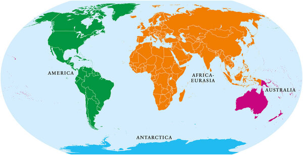 Four continents world map. America, Africa-Eurasia, Australia and Antarctica. Political map with shorelines and borders. Robinson projection. English labeling. Isolated on white background. Vector.
-
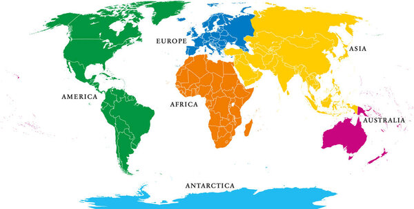 Six continents, political world map, with borders. Africa, America, Antarctica, Asia, Australia and Europe. Robinson projection. English labeling. Isolated illustration on white background. Vector.
-
 Five continents, world map. Africa, America, Antarctica, Australia and Eurasia. Outline and colored shapes under Robinson projection. Isolated on white background. Vector.
-
 World color map continents
-
 World map, colorful continents atlas EPS10 vector file.
-
 Set of monochrome icons with continents for your design
-
 Watercolor map Australia pink blue
-
 World map colored by continents
-
 Illustrated map of the world with all continents
-
 World Continents
-
 Australia minimal bright yellow material icon
-
 Australia Flat four color minimal icon set
-
 Australia Green and yellow modern 3d vector icon logo
-
 Political World Map vector illustration with different colors for each continent and isolated on white background. Editable and clearly labeled layers.
-
 Set of vector globe icons showing earth with all continents. Vector illustration.
-
 World map with travel routes, destinations and landmarks from all continents: vacations and traveling concept
-
 Continents Pictogram
-
 Political World Map vector illustration with different colors for each continent and different tones for each country. Editable and clearly labeled layers.
-
 Continents and countries on the world map marked.
-
 Seven continents vector
-
 Character from Australia (Aboriginal) dressed in the traditional way with didgeridoo Vector Illustration. Kids of the World Collection.
-
 Australia map vector illustration. Global economy. Famous country. Oceania region
-
 Blank political map of Australia. 3D Earth globe with colored map. Vector illustration
-
 Black and White Educational Cartoon Illustration of Australian Animals Set and World Map with Continents Shapes Coloring Book Page
-
 Australia map illustration hand drawn outline vector
-
 Map of Australia with internal regional boundaries, vector illustration
-
 Vector illustration of a world map with continents in different colors. Perfect for education, geography, travel, and infographic projects.
-
 World color map continents and country name
-
 Continents vector maps country infographics set. Slides presentation templates with flags
-
 Illustration of the continents of the worls on white background
-
 Earth - Australia
-
 Continents vector map illustration. World map divided into six continents. Simple flat vector illustration.
-
 Black and white educational cartoon illustration of African animal species and world map with continents shapes coloring book page
-
 Silhouette of a world map with all continents and large Islands, all countries, vector
-
 Blank political map of Australia. 3D Earth globe with black outline map. Vector illustration
-
 Vintage world map. Retro countries boundaries on topographic or marine map. Old continents navigation maps vector illustration
-
 Political world map on transparent background, black color earth continents silhouette vector illustration
-
 World Map vector. Blue similar world map blank vector on white background. Blue similar world map with borders of all countries, States of USA map, Provinces and territories of Canada and States and territories of Australia. EPS10.
-
 World Map vector. Gray similar world map blank vector on transparent background. Gray similar world map with borders of all countries and States of USA map, States of Australia and Countries of the UK. Quality world map.
-
 Earth's city lights map with silhouettes of continents
-
 7 continents in the world with white background
-
 Political world map on white background, with every state labeled and selectable. Colored by continents. Versatile file, turn on an off visibility and color of each country in one click
-
 Dot Style World Map With Continents
-
 World map divided into six continents in different color. World map 6 continents isolated on white background. Vector stock
-
 Match animals and continents shapes educational game
-
 World map vector aesthetic color states border geography continent global business travel flat graphic earth globe planet worldwide vector illustration country name text
-
 WORLD on a black background China, India, Middle East and Australia
-
 World map vector states border geography continent global business travel flat graphic earth globe planet worldwide black background
-
 Map of the world. World map. Vector design.
-
 Dotted world map
-
 Vector Pixelated Topographic World Map Miller projection
-
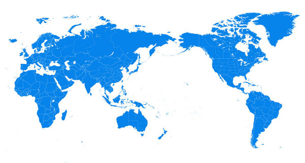 World Map - Pacific China Asia Centered View - Blue Color Political - Vector Layered
-
 Vintage colors vector political World Map
-
 Orange detailed world map with Earth globes
-
 Colorful vector world map complete with all countries and capital cities names.
-
 World map countries colorful. Vector illustration.
-
 World map paper in vector
-
 High detail world map. vector illustration of earth map
-
 Vector outline of political world map
-
 Six black and white vector Earth globes
-
 Flags of the world in globe. Vector illustration.
-
 Animals world map
-
 The Earth
-
 Political map of World
-
 Pacific Ocean Physical Map White and Grey On Black
-
 Navy map of the world.
-
 Abstract glossy globe
-
 Australian map
-
 World Map vector. White similar world map blank vector on gray background. White similar world map with borders of all countries and States of USA map, and all States of Brazil map. High quality world map. EPS10.
-
 Vector detailed political world map
-
 World map with countries names.High detailed Vector world map complete with all countries names in blue background drawing by illustration
-
 Political simple world map Equirectangular projection
-
 Highly detailed political World map with labeling
-
 World Map Black Color Pacific Centered. Detailed World Map Vector illustration.
-
 Highly detailed map of the world with countries, big cities and other labels,updated with South Sudan,Kosovo and North Macedonia
-
 Darwin day
-
 World map with graticule
-
 Political World Map vintage color with lakes and rivers
-
 February 12
-
 Detailed World Map
-
 World Map and Flags - borders, countries and cities -vector illustration
-
 Vintage World Map - Vector Illustration
-
 Vector map of animals on a black background
-
 Modern Detailed Globe Map Isolated on White Background in Light Grey Color. Vector Illustration
-
 Colorful Classic Robinson projection vector map of the World, cleverly layered and with names of all countries, capitals and main cities, main geographical features.
-
 World map of Pangaea, Laurasia, Gondwana and sea Tetis
-
 Vector Timezone world map
-
 Map of the world silhouette
-
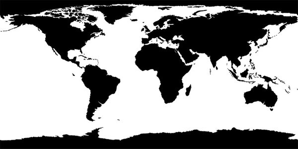 World Map Texture
-
 Vector map of the world with animals and plants
-
 High Detailed Political countries World Map. Vector illustration
-
 World Map with Country Name and Detailed Country Colors Territory
-
 Seamless vector pattern with animals on the world map
-
 April 25
-
 Highly detailed political world map
-
 Colored World Map Blank. Detailed World Map vector illustration.
-
 World map in french language
-
 Political map of the world with countries separated by colors on a dark blue
-
 Detailed World map standard time zones
-
 Beige map of the world.
Each vector opens in a new tab with its details. Premium files are sold by Depositphotos; we may earn a commission if you buy. How this works.