Central usa vectors
100 central usa vector illustrations picked from 17M royalty-free files, with no more than 3 per artist so you see real variety. Every file is a scalable EPS that opens in Illustrator, CorelDRAW, Affinity Designer and Inkscape, and exports to SVG or PNG at any size.
-
 Texas state map icons with vector flag stars, blue, red and white stripes, lines and bull head. Silhouettes of Texas map, South Central region of USA country emblems, the lone star state prints
-
 North and Central American States Waving Flag Set. The set includes the flags of USA, Canada, Mexico, Guatemala, El Salvador, Honduras, Nicaragua, Panama and Costa Rica. Vector Icons neatly on Layers
-
 United States Central Command flag, USA, vector illustration
-
 Welcome to New York poster for USA travel of America famous landmarks and tourist attractions, Liberty Statue and central park city skyline
-
 USA and Angola, Cameroon, Democratic Republic of Congo, Republic of the Congo, Central African Republic Flag. 3d vector puzzle. Set 25.
-
 Large and detailed map of Gilpin County in Colorado, USA.
-
 Usa travel color icon vector illustration
-
 Made In The USA Silver Badge
-
 North and Central America
-
 The Americas, geoscheme and political map. The North American subregion with intermediate regions Caribbean, Northern and Central America, and the subregion South America. Subdivisions for statistics.
-
 Puerto Rican flag from Puerto Rico, unincorporated territory of the USA - isolated vector illustration
-
 Central Park. Urban park in Manhattan, New York City, United States, vector illustration
-
 Cover for brochure with USA image and American flag
-
 New York Central Park Poster. Travel vintage postcard, autumn. Vector illustration retro
-
 Cover for brochure with USA image and Am
-
 Cover for brochure with USA image, American flag and freedom mo
-
 USA and Mexican grunge Flag
-
 Tourist infographics about America. Cartoon map of USA. Travel illustration with landmarks, buildings, food and plants. National symbols. Famous attractions. Vector illustration
-
 Usa virgin island flag isolated in the wind
-
 Highly detailed vector silhouettes of US state maps, Division United States into counties, political and geographic subdivisions of a states, West South Central - Arkansas, Louisiana, Oklahoma - set 12 of 17
-
 Made In The USA Gold Badge
-
 USA time zones infographic map. Colorful United States of America geography time zones. Stock vector illustration isolated
-
 North and Central American flag set
-
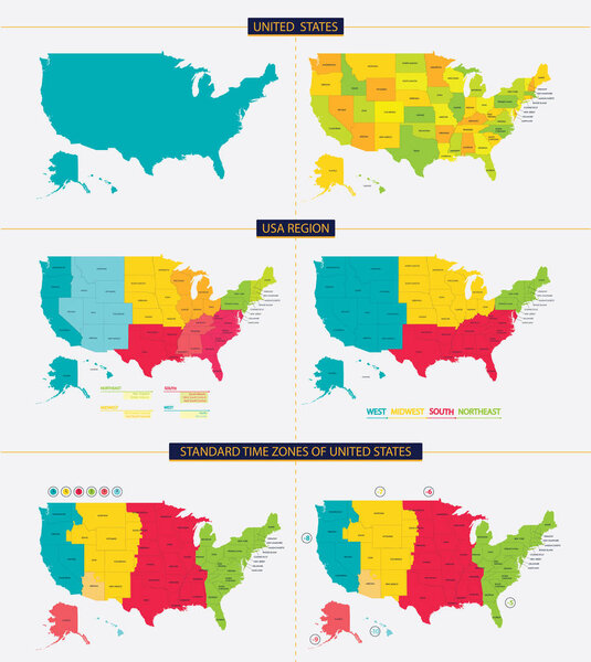 United states. Standard time zones of united states. USA region
-
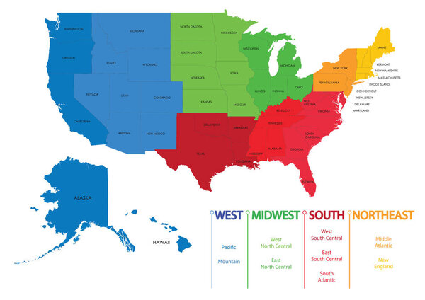 Map of US regions. Maps USA
-
 North America, political map with borders of states, provinces and territories of Canada, USA and Mexico. Continent bordered by South America, the Caribbean Sea, Arctic, Atlantic and Pacific Ocean.
-
 Vector illustration. Central Park, New York. Design for poster, postcard, banner, notebook cover.
-
 Louisiana, LA, political map, with capital Baton Rouge and metropolitan area New Orleans. State in Deep South and South Central regions of the United States, nicknamed Pelican, Bayou and Creole State.
-
 Highly detailed vector silhouettes of US state maps, Division United States into counties, political and geographic subdivisions of a states, East South Central - Mississippi, Kentucky, Tennessee - set 11 of 17
-
 Political map of North American countries Canada, United States of America, Mexico with administrative divisions. Central American Countries and Caribbean Region. Colorful blank map. Vector
-
 Highly detailed vector silhouettes of US state maps, Division United States into counties, political and geographic subdivisions of a states, Mountain and West South Central - Colorado, New Mexico, Texas - set 13 of 17
-
 Sketch of a central park, New York, hand drawn vector illustration. Vector illustration
-
 Map of the city of Cincinnati, State Ohio, USA, , and is the government seat of Hamilton County
-
 Layered editable vector illustration of the subway diagram of Boston,USA.
-
 USA, Canada, Brazil and Mexico flags
-
 USA national flag collection, eight versions of United States vector flags. Vector illustration.
-
 Made In The USA
-
 USA Map Illustration
-
 New York city doodles elements. Hand drawn set with, taxi, coffee, hotdog, statue of liberty, broadway, music, coffee, newspaper, museum, central park. Drawing doodle collection, isolated on white
-
 Caribbean islands Central America map state names card colors 3D vector
-
 Hand drawn sketch of Central park in New York city.
-
 Layered editable vector illustration of the subway diagram of Washington,DC,USA.
-
 Texas state icon map set
-
 Country design template
-
 New york city flag
-
 New York
-
 The letters NYC on the landscape of new York
-
 New York City
-
 Blue similar New York map. New York map blank. New York map vector. New York map flat. New York map template. New York map object. New York map eps. New York map infographic. New York map clean.
-
 I love new york line icon vector illustration
-
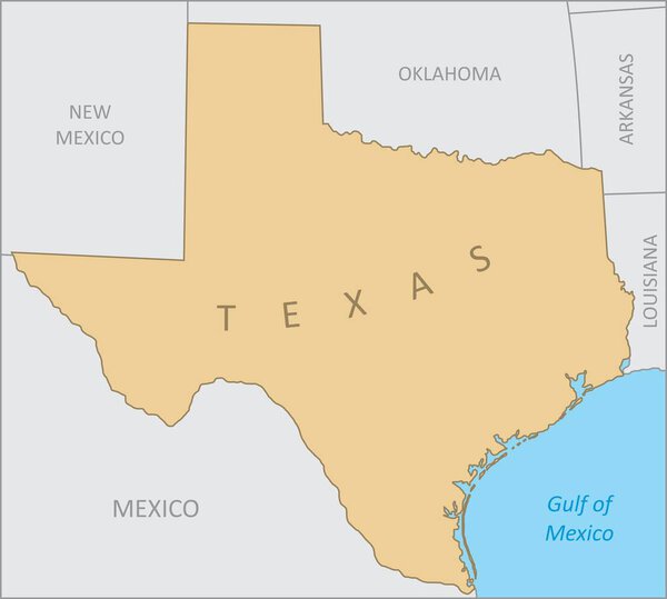 Texas region map
-
 Vector New York state Map silhouette. Isolated vector Illustration. Black on White background.
-
 New York Manhattan Illustration Map
-
 New york night
-
 Louisiana State and Date
-
 North America road map with labeling
-
 Flag of Puerto Rico
-
 Black and white printable New York city map, poster design, vector illistration.
-
 List of streets in New York City
-
 North America administrative vector map with latitude and longitude
-
 ������������
-
 United states time zones map
-
 Flat Flag of North American Country of United States of America
-
 Iowa State. Word Grunge collage on background.
-
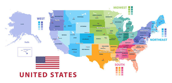 United States census bureau regions and divisions vector map. Flag of United States of America
-
 Flag of United States - Vector illustration.
-
 United state of America flag
-
 Flag of United States in grunge style with waving effect, vector grunge brush stroke flag.
-
 United States round flag icon with shadow.
-
 Postage stamp with America flags. Set of 42 American flag.
-
 Vector Set of buttons flags of America
-
 Vintage tin sign collection with America state. Washington. Idaho. Oregon. South. North. Retro souvenirs or postcard templates on rust background.
-
 Texas Banner
-
 All national flags of the countries of American continents in alphabetical order. Official colors flags and round design. Vector illustration
-
 North America - map - illustration.
-
 Detailed map of US regions, isolated states with names, Colorful infographics of the United States of America, vector illustration
-
 Flag of California, United States
-
 Gulf of America simple map. The Gulf of Mexico may be renamed The Gulf of America.
-
 New York map
-
 List of streets in New York City, word cloud collage, business and travel concept background
-
 CIA Logo Mockup
-
 American continent flags
-
 Dark grey detailed blank political map of CANADA with black state borders on transparent background using orthographic projection of the light grey North American continent
-
 North America map and country contours - Illustration.
-
 Kentucky State and Date
-
 Kansas State and Date
-
 Dark blue detailed blank political map of the UNITED STATES on transparent background using orthographic projection of the light blue North American continent
-
 Collage with various words with New York
-
 New York American City Landmarks Icons Set Vector
-
 North and South America Political Map and Flat Map Markers
-
 Political Map of Mexico
-
 Fresno on California State Map. Detailed CA State Map with Location Pin on Fresno City. Black silhouette vector map isolated on white background.
-
 Waving Texas Flag Isolated On A White Background. Vector Illustration.
-
 Map of Mexico with national borders, main cities and rivers
-
 Vector detailed map of North America and Greenland with borders and country names.
-
 Welcome to Wisconsin road sign
-
 New York city typography
-
 Vector illustration of the City of Yonkers green road sign
-
 North America Region. Map of countries in northern America. Vector illustration
-
 Vector flags of countries as fabric badges
Each vector opens in a new tab with its details. Premium files are sold by Depositphotos; we may earn a commission if you buy. How this works.